Saturday, 23 June 2018

Bangor, North Wales


The city of Bangor in North Wales has a very long history. It was also a special place in my youth as the home of my “alma mater” university!

Despite the existence of an earthwork known as “Roman Camp” there is no evidence of Roman occupation here, although they almost certainly passed this way on their way to invade Anglesey in 60 AD. Roman Camp is probably of Norman origin.

A Celtic monastery was founded here in the 6th century, as well as a bishopric that was one of the earliest in Britain. Bishop Deiniol was consecrated in 546 and was later declared a saint. It was after him that the cathedral, founded in the 12th century, was named.

The current cathedral does not contain much material from earlier centuries, being largely the result of extensive 19th century renovations conducted by Sir George Gilbert Scott. Plans to include a high tower and spire were abandoned when there was concern over whether the foundations were strong enough. The result is a somewhat squat building that is not all that distinguished, especially giving the cathedral’s site in a valley between prominent ridges.

Far more noticeable is the main Arts Building of Bangor University, sited on the north-western ridge. This is sometimes mistaken by visitors for the Cathedral, although it more resembles an ocean liner than a place of worship. The University was opened in 1885 (as part of the University of Wales) and is therefore contemporaneous with the restored Cathedral.

I was a student there in the early 1970s and have “fond” memories of having to climb the hill to the college early in the morning then walk up several flights of stairs to the top floor of the College for Philosophy seminars in the Professor’s office! I was a lot fitter then!

Education is now Bangor’s major “industry”, with many buildings across the city being part of the University.

Visitors to the city may be interested to take a walk in the “Bishop’s Garden”, alongside the Cathedral, which aims to include a specimen of every plant mentioned in the Bible that can stand the rigours of the North Wales climate.

Penrhyn Castle, on the eastern approach to Bangor, is owned by the National Trust for Wales and open to the public. It may appear to be of Norman origin but that is an illusion because most of it was built in the 19th century. It houses interesting displays including artworks and a railway museum.

West of the city is the Menai Suspension Bridge to Anglesey, built by Thomas Telford in 1826. Many pleasant walks can be taken across the bridge and alongside the Menai Straits.
 

© John Welford

Thursday, 21 June 2018

Grange-over-Sands, Cumbria


The sands in question are those on the edge of Morecambe Bay in north-west England, which is renowned for the huge distance to which the sea recedes at low tide and the speed with which it returns when the tide turns.

Grange-over-Sands began as a quiet fishing village that was “discovered” by the Victorians who liked the year-round mild climate of this sheltered resort, backed by woodland. A sanatorium was established for the treatment of tuberculosis sufferers.

A mile-long promenade curves round the shore, fringed by gardens that feature rare trees and shrubs.

Two miles north is Lindale-in-Cartmel, where a 12 metre high iron pillar forms a monument to John Wilkinson (1728-1808), an ironmaster who lived locally in his youth but went on to build the world’s first iron bridge at what was henceforth known an Ironbridge Gorge in Shropshire.

To the east of Grange-over-Sands is Cartmel Priory, which was founded in 1188 and managed to escape the ravages of King Henry VIII’s Dissolution of the Monasteries by virtue of establishing its claim to be the local parish church. The name “Grange” means farmstead, the original village having this function on behalf of the Priory.

© John Welford

Monday, 18 June 2018

Dunbar, East Lothian, Scotland


Dunbar, which is a small town on the East Lothian coast 28 miles east of Edinburgh, may be quiet and peaceful these days, but it had a turbulent past.

Generals taking armies between England and the Scottish capital preferred the coastal route because they could keep their men supplied from the sea, and Dunbar was therefore a place to be defended or attacked, depending on whether one was Scottish or English.

In 1296 the defenders were routed by the troops of King Edward I, but things were different in 1338 when “Black Agnes”, the Countess of March and Dunbar, defended the town’s castle for six weeks from an attack led by the Earl of Salisbury. She was relieved by a raiding party from the sea.

The bloodiest battle to take placed at Dunbar was in 1650, when Oliver Cromwell’s Roundheads were trapped in the town by Scottish Covenanters and outnumbered by two to one. The Scots held a strong position on Doon Hill but unwisely abandoned it in order to prepare for a battle on the plain below the hill. Cromwell spotted this move and surprised the Scots with a dawn raid that completely defeated them.

Five years later Cromwell gave the town funds to enable them to build a new harbour.

Today, Dunbar only has a small fishing fleet but is popular with walkers and golfers. It was the birthplace of John Muir (1838-1914) who spent most of his life in the United States, where he became a noted environmentalist and the founder of Yosemite National Park. His birthplace in Dunbar is now a museum.

The ruined 14th century castle overlooks the harbour mouth.

© John Welford

Paddington Station, London


London’s Paddington Station was designed by the chief engineer of the Great Western Railway, Isambard Kingdom Brunel (1806-59). His plans were drawn up at the end of 1850 and the building was completed in 1855.

These dates are significant, because they coincide with the creation of the Crystal Palace that was built to house the Great Exhibition of 1851. Joseph Paxton’s masterpiece of metal and glass no longer exists, but its influence was clearly evident in Brunel’s thinking. Not only that, but the engineers who built Paddington Station – Fox, Henderson and Co – were also the contractors for the Crystal Palace.

Paddington Station consists of three glass-roofed vaults, the widest of which spans more than 100 feet, with two “transepts”, or crossing points, that were originally designed so that locomotives could make “three point turns” before the invention of the turntable. Brunel needed plenty of space for this, given that the Great Western was based on the “broad gauge” system in which the tracks and trains were three feet wider than those currently used.

Practicality was combined with artistry, in which Brunel was aided by Matthew Digby Wyatt (1805-55) who designed the decorative detailing of the ironwork and brickwork.

Brunel’s visionary aim was to transport passengers in comfort all the way from London to New York, via the Great Western to Bristol then by his steamships across the Atlantic. Paddington Station would be where the journey would begin, so passengers could enter a palace of the steam age and enjoy opulence all the way.

The steamships no longer ply their trade from Bristol, but the Crystal Palace of Victorian engineering still stands as a monument to the dream. It is also perfectly possible to travel via Paddington to New York, by taking the “Heathrow Express” to Heathrow Airport!
© John Welford

Saturday, 16 June 2018

Deddington, Oxfordshire


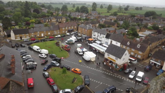
This is Deddington, which is a large village about five miles south of Banbury in Oxfordshire, England. The photo was taken from the roof of the church tower and shows the main square with the monthly farmers’ market in full swing.

There has been a community here for at least 1,000 years. It is mentioned in Domesday Book as Dadintone, which was owned at the time by Odo, the Bishop of Bayeux who was a half-brother of William the Conqueror. Odo built a castle, the site of which can still be seen with the banks that surrounded the large outer bailey, but not a single stone remains in place.

At the time of the Domesday survey (which was commissioned in 1087) Deddington had “land for 30 ploughs, 140 acres of meadow and 30 acres of pasture”. There were three mills that produced an annual income of 41 shillings and supplied 100 eels.

Local produce today, to judge by what was on offer at the market, is a bit more varied. One stall, for example, specialised in low-sugar chocolate made with unusual flavours including lavender and vanilla. Another stall sold nothing but mealworms as bird food – the stallholder bred them as a sideline when not working at the local Co-op store!

The houses are typical of this area, being built in light brown Cotswold stone. These days they sell for prices that are well above the national average, given their desirable location (only ten miles north of Oxford) and the extremely attractive nature of the surrounding area.

The fire engine was not on duty, being there merely as a bit of publicity for the local Fire Service and to give local children a chance to sit behind the steering wheel and try on a fireman’s helmet! 

© John Welford

Monday, 7 May 2018

The Antonine Wall, Scotland


Most people have heard of Hadrian's Wall which was built on the orders of Emperor Hadrian across northern England and completed around the year AD 128. The Emperor had decided that there was a limit as to how far north the Empire could be extended, and this was it. Although he was happy for trade to continue with the people living north of the Wall, he saw no point in imposing Roman rule on them and undertaking the expense of so doing.

However, his successor as Emperor had other ideas. This was Antoninus Pius, who ruled from 138 to 161. He believed that the Empire could include the whole of what is now Northumberland and southern Scotland, and so he ordered the building of a new wall to link the Firth of Clyde to the Firth of Forth. This marks the ‘waist’ of Scotland and is therefore a distance of only 37 miles as opposed to the 73 miles of Hadrian’s Wall.

Despite the much shorter distance and inferior structure – turf-faced earth ramparts as opposed to solid stone – the new wall took longer to complete, namely twelve years from 142 to 154. Antoninus was, however, confident that he had gone one better than his predecessor and Hadrian’s Wall was allowed to fall into disrepair as the border moved to its new location.

The Emperor’s confidence was not shared by his own successor, namely Marcus Aurelius. This was mainly because the reign of Antoninus was remarkably peaceful and he faced no serious threats from north of his wall, or anywhere else for that matter. Marcus Aurelius was not so lucky and he therefore decided that Hadrian’s Wall was preferable to Antoninus’s as a defensible position. The Antonine Wall was therefore abandoned.

Finding the Antonine Wall

This is not at all easy, for the reasons mentioned above. Without constant maintenance an earth rampart is always going to be subject to erosion, especially in a country that is subject to as much wind and rain as Scotland!

Another problem is that whereas Hadrian’s Wall strode for the most part across barren open countryside and made use of dramatic natural features such as the Great Whin Sill, the territory crossed by the Antonine Wall has been used for many other purposes in the years since its abandonment, such as the construction of towns and the links between them. The western part of the route is today covered by the urban sprawl of Glasgow and its surrounding communities.

The Wall might never have been re-discovered, and partly preserved, had it not been for the work of William Roy, a surveyor and antiquarian who located and mapped as much of it as he could find in 1764.

Walking the Way

The fact is that you cannot ‘walk the Wall’ in the same way that you can at Hadrian’s Wall. However, there are a number of short walks you can undertake from which you can view what remains of the Wall at various points along its length. Here are some suggestions, from east to west:

Falkirk

There is a well-defined section of Wall in the grounds of Callendar House, on the southern edge of Falkirk. 

Further west is a section at Tamfourhill, to the south of Camelon (a suburb of Falkirk). A walk here can take you along the Forth and Clyde Canal and you should not forego the opportunity to visit the amazing Falkirk Wheel that lifts boats between the Forth and Clyde and Union Canals.

Rough Castle (near Bonnybridge)

This is the best preserved fortification to be seen on the Antonine Wall, with its ramparts and ditches clearly visible. There is a half-mile length of the wall that you can walk along here in open countryside, with views to both north and south (see photo above).

Other sections

Short sections of the Wall can also be seen at Polmont Wood (near Grangemouth at the eastern end) and Seabegs Wood (parallel to the Forth and Clyde Canal, west of Bonnybridge)
© John Welford

Monday, 2 April 2018

Lyveden New Bield, Northamptonshire


High up on open downland in Northamptonshire stands a remarkable building that was the brainchild of an extraordinary man. When he died in 1605 his dream died with him, but it has remained ever since just as he left it .
Sir Thomas Tresham
Born in 1543, Thomas Tresham came from a wealthy and well-connected Northamptonshire family that was staunchly Catholic and had prospered during the reign of Queen Mary I (1553-8). 
Thomas became head of the family in 1559 at the early age of 15 but continued with his studies, being admitted as a lawyer of the Middle Temple when only 17. 
The Elizabethan age was one in which people with talent and the right connections could become extremely wealthy and tended to spend their wealth on building magnificent houses, many of which can still be seen today. Thomas Tresham never had the wealth of people like William Cecil (the builder of Burghley House), but that did not stop him from going on a building spree of his own.
Tresham’s main problem was his adherence to the Catholic faith at a time when this was becoming positively dangerous. During the early part of Elizabeth I’s reign this was no impediment, as is evidenced by Thomas Tresham being knighted by the Queen in 1575, but after the attempted invasion of England by King Philip of Spain in 1588, being a Catholic in England was tantamount to being a foreign agent. Practicing Catholics had to keep their heads down or risk a terrible punishment.
Thomas Tresham found that his net wealth was severely depleted during his later years, mainly through having to pay fines for not attending Anglican church services. Much of the building work was therefore financed through borrowing money that he was never able to repay.
He also spent a considerable amount of time in prison, being arrested as a political hostage at any time that the government suspected that the safety of the realm was under threat from foreign Catholics.
Another problem for the Treshams, following the death of Queen Elizabeth in 1603, was that Francis, Thomas’s elder son and heir, became involved in the Gunpowder Plot to overthrow the government of King James I. It is known that the Plot failed because an anonymous message was sent to Lord Monteagle warning him not to attend the opening of Parliament because a ‘great blow’ could be expected. It is entirely possible that the warning was sent by Francis Tresham.
Sir Thomas Tresham died in September 1605 and Francis Tresham was soon under arrest after the failure of the Gunpowder Plot in November. He died in December before coming to trial. His younger brother Lewis inherited the estate but also the massive debts that came with it. The building ventures of Sir Thomas therefore came to a grinding halt at his death.
Sir Thomas the builder
Thomas Tresham’s first building venture was the Market House at Rothwell, which is the nearest town to Rushton, where he was lord of the manor. This was a gift to the town and is notable for the carved coats of arms of ninety local families. This was started in 1578 but not finished during Sir Thomas’s lifetime. Indeed, it had to wait until 1897 for the roof to be added!
His second venture, however, was completely different. This was the Triangular Lodge on his Rushton Estate, built between 1593 and 1597. The building was used to house the man who looked after the rabbit warrens on the estate, but it has all the characteristics of a ‘folly’ in that its true purpose was devotional. It is a temple to the Trinity, with the focus on the number three – three sides, three floors, three gables on each side, etc, etc. 
The Triangular Lodge was far from complete when Sir Thomas started work on Lyveden New Bield (which means ‘New Building’). He also did some work on his main residence, Rushton Hall, at the same time.
Started, but never finished
Lyveden is about nine miles to the east of Rushton and was the Treshams’ second estate. There was already a manor house here (Lyveden Old Bield, dating from the 14th century) but Sir Thomas had the idea of building a ‘garden lodge’ at the top of the hill behind the manor house. He would also create an artificial landscape of terraces and canals, all for the purpose of entertaining guests, playing the role of country gentleman and also indulging his fetish for religious symbolism based on numbers.
The size of the building as it exists today, plus the apparent plan to make it even bigger, suggests that Sir Thomas had a great deal of entertaining in mind. There would have been plenty of room for many guests to be accommodated, plus the necessary servants, but it is doubtful that he intended to make the house his principle place of residence.
Work started in 1594 but it must have been very frustrating for Sir Thomas that he was prevented from overseeing the construction in person by virtue of being held under house arrest or in prison for much of the time after this date. At the time of his death in 1605 the New Bield was a roofless three storey structure, which is just what visitors can see today. The work stopped when Sir Thomas died and never restarted. 
The quality of the materials and workmanship was such that the house looks almost as though the workmen have just downed tools for the weekend but will be back to carry on in a few days’ time. Despite the exposed site there has been very little damage due to storm or erosion, and efforts to remove stone for other building work have proved fruitless – it was too well built to be demolished. 
It is more than 400 years since Sir Thomas and his dream died, so what you can see today is a time capsule of Elizabethan house-building and landscape gardening.
From the look of the New Bield today it would seem that all that is missing is the roof, but there is evidence to suggest that a further storey was planned before the roof would have been added.
Another careful plan
As mentioned above, Sir Thomas was obsessed by the number three at Rushton Triangular Lodge, which is a celebration of the Trinity (Father, Son and Holy Ghost). At Lyveden the numbers five and seven also played dominant roles. The symbolism of five is that Christ suffered five wounds on the cross, and seven has long been regarded as a ‘holy number’, as evidenced by its frequent use in the Book of Revelation.
The ground plan of the New Bield is four arms with a central space, making five. Each arm ends in a five-sided bay, with each side measuring five feet. Five fives are twenty-five, which is the date of Christmas in December and the Annunciation in March.
As mentioned above, it looks as though Sir Thomas may have planned to build three storeys (not counting the basement which was the domain of the servants). Above the windows are sets of three shields and there are diamond decorations in groups of three. The distance from one side of the building to the other is 243 feet – a multiple of three.
The number seven is represented by the frieze between the ground and first floors, which displays roundels depicting the seven emblems of the Passion of Christ.
The frieze above the first floor is no longer complete, but originally comprised a set of Bible texts in Latin. These were arranged so that the words IESUS and MARIA appeared each side of each bay window, accompanied by the Tresham emblem of a three-leaved clover.
Inside the building
Visitors have to use the servants’ entrance which is down a few steps to the basement level. That is because the interior of the building is an open shell with no floors, although there are many holes in the stonework to show where joists were intended to be fixed. Guests would have used an entrance at the ground floor level on the opposite side to the servants’ entrance. This ‘front door’ would have been reached by a set of steps leading via a small porch to a room in which a niche – still visible – would have contained a statue of the Virgin Mary.
The basement shows evidence of what the building was intended to be used for, namely the accommodation and entertainment of guests. You can see where the large bake ovens and the copper for heating water would have been. You can also see that Sir Thomas wanted to preserve the external symmetry of the building by incorporating all the rainwater pipes and flues from the fireplaces within the walls. This would have helped to allow uninterrupted views to be had from the planned rooftop walk that guests would have been able to enjoy after their evening meal on fine summer evenings.
As you look up from the basement you can see signs of how the upper floors would have been arranged. For example, the Great Chamber would have been on the first floor, as is apparent from the intricate stonework decorations at this level.
In the grounds
The grounds of Lyveden New Bield are just as remarkable as the building itself. Sir Thomas employed a large force of gardeners and labourers to create a totally artificial environment close to the house that involved banks, ditches, spiral mounts and moats. His plan was to emulate the great gardens of European mansions by creating one of his own on top of a hill in Northamptonshire.
Given that there are no natural water courses up here – no streams to be dammed to form a lake – the only recourse was to dig his moats to a depth of about three or four feet, line them with clay, then wait for rain to fall on the banks and drain into the prepared ditches. The plan clearly worked, because the water courses are still there to this day. The moats were stocked with fish – as they are now – and guests could be rowed in a boat as they tried to see them.
There are two spiral mounts in the grounds that were modelled on similar mounts built by other Elizabethan landowners. The idea was that guests could take a leisurely stroll up the winding path and enjoy the view from the summit, much as they could do from the rooftop walk mentioned above. 
As with the house, the garden project was never completed. Sir Thomas had originally planned a four-sided moat with the central area being planted as an orchard. There would also have been four viewing mounts rather than two. As it stands, the moat is three-sided and two of the mounts are much smaller than the completed ones with their spiral walkways.
There is, however, an orchard on the side of the moat facing the Old Bield. Efforts have been made in recent years to replant this orchard with varieties that the Treshams would have known. This has been done by grafting specimens from the National Collection of fruit trees on to vigorous rootstocks.
A very pleasant time can be spent at Lyveden New Bield, which is preserved and managed by the National Trust. The site has survived so well after 400 years that is not difficult to imagine how the dream of Sir Thomas Tresham could have been fulfilled.
© John Welford