Thursday 31 December 2015

The Lost Gardens of Heligan


The story of Heligan

The Heligan estate, five miles south of St Austell in Cornwall, England, was acquired by the Tremayne family in the 17th century. A succession of Tremaynes, in the 18th and 19th centuries, developed the grounds and introduced a number of exotic plants that could thrive in the mild climate of Cornwall, and especially the micro-climate created by the steep-sided valley that leads away from Heligan House.

Early in the 20th century the gardens provided full-time employment for 22 people, but then came major changes that threatened their very existence. Sixteen of the gardeners were killed in the First World War, and in the 1920s the owner decided to move to Italy and lease the house to tenants. Eventually the house was sold and the gardens were allowed to grow wild and thus be “lost”.

It was not until the early 1990s that work started to restore the gardens, this work being done largely by volunteers. The gardens are now a major attraction and a valuable resource in terms of their botanical contents and as a reconstruction of a Victorian estate garden.


What you can see


The gardens are divided into two main sections, Productive and Pleasure, which are themselves split into distinct areas.

The Productive gardens include a walled flower garden, a melon yard and a vegetable garden. More than two hundred varieties of fruit and vegetables are grown here.

However, most visitors come to see the Pleasure gardens which comprise a series of individual garden scenes. There is a New Zealand garden, an Italian garden, a crystal grotto and a sundial garden.

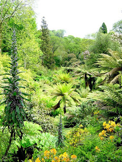
Perhaps the most remarkable section is the “jungle”, in which plants from tropical parts of the world are able to grow and thrive, including giant ferns and banana plants. The path takes visitors past four linked ponds that provide some wonderful vistas of the largest collection of palms and tree ferns in the United Kingdom. All that is missing is snakes and birds of paradise!

The gardens offer many surprises, including sculptured forms of maidens and giants that seem to grow out of the ground covered in plants.

It is not surprising that, since their discovery and restoration, the Lost Gardens of Heligan have become the most popular private gardens in Britain, with more than 200,000 visitors every year.


© John Welford

Tuesday 29 December 2015

The Seven Sisters, East Sussex


The Seven Sisters are a series of sheer chalk cliffs, up to 500 feet high, on the coast of East Sussex between Newhaven and Eastbourne. Geologically they are part of the South Downs and are now included in the South Downs National Park that was created in 2011.

The Seven Sisters were formed when a series of parallel valleys was cut into the chalk by streams that flowed when vast quantities of water were released by melting glaciers during the last ice age. The amount of rain that falls under normal conditions is not enough to keep the streams flowing, given that most of the water percolates down into the soft chalk to leave “dry valleys” behind. As the cliffs have been eroded by the sea the valleys have been left as vertical indentations in the line of the cliffs, resulting in the “sisters” standing up prominently between them.

The name “Seven Sisters” comes from Greek mythology, in which they were the seven daughters of Atlas and Pleione. When they died they were turned into the stars of the Pleiades cluster, which is also known as the Seven Sisters. However, one small problem with the Sussex version is that there are, in fact, eight distinct peaks! To be fair, there were originally seven (named Haven Brow, Short Brow, Rough Brow, Brass Brow, Flat Brow, Baily’s Hill and Went Hill) but cliff erosion has led to an eighth sister appearing which has been named Flagstaff Brow.

The best view of the Seven Sisters, except from out at sea, is from Seaford Head to the west, as the land sticks out into the sea at this point and affords a view all along the coast as far as the Belle Tout lighthouse (now used as a guesthouse, the lighthouse had to be moved back from the cliff edge in 1999 to prevent it from falling into the sea!). There is a track that leads across Seaford Head down to sea level, with the view changing all the way. Seen from the beach, the full height of the cliffs can best be appreciated.

It is possible to walk along the foreshore below the Seven Sisters from Cuckmere Haven at the western end to Birling Gap at the eastern end, but there are good reasons for not doing so. Although the distance is only about three miles it is across rough rocks that are covered in seaweed and thus extremely slippery. It is not safe to walk close to the cliffs, because of the danger of rocks falling from above, which is a regular event with unstable chalk cliffs. If you are caught by the incoming tide there is no way up the cliffs apart from at either end of the Seven Sisters.

However, there is nothing to stop you from walking a short way along the foreshore at low tide from either end, which you might want to do if you are interested in finding fossils, which are plentiful at this location. Great care should be taken when doing so, and anyone who ventures close to the cliff base should wear a hard hat. Given that chalk is composed of the remains of small marine animals, it is always possible to find microfossils in the chalk, which can be discovered from lumps of rock taken from the foreshore and then examined later under a microscope.

Apart from appreciating the full height of the cliffs from sea level, you might also take note of the different chalk strata that were laid down over millions of years during the Late Cretaceous period around 83 to 89 million years ago. Also notable are the dark bands of flint that run horizontally through the chalk. Along the foreshore are the remains of several shipwrecks, including a World War I German submarine which can be seen at low tide near Birling Gap.

Another way to appreciate this area is from the tops of the cliffs, by walking a section of the South Downs Way between the Seven Sisters Country Park and Birling Gap (or on to Beachy Head and Eastbourne).  The walk, which is widely regarded as being one of the finest in south-east England, starts a short distance inland (there is no public road access to the point at which the Cuckmere River reaches the sea). The first part of the walk is across fairly flat ground alongside the river, but then the path rises steeply as it turns eastwards to surmount the first Sister. After that it is up and down all the way as you climb each Sister in turn! However, the effort is well worth taking for the spectacular views from the summits, both out to sea (you can see the French coast on a fine day) and inland.

The path takes you quite close to the cliff edge but it is sensible not to get too close, due to the crumbly nature of the chalk as mentioned above. The distance is about five miles and there is a return route, if preferred, that takes you inland through Friston Forest. The full route from Seaford to Eastbourne via Beachy Head is about fourteen miles long.

While on the cliff-top path it is worth taking time to appreciate the very special fauna and flora of the downs. This is land that has been carefully managed and preserved and which therefore contains many rare plants that are seen in few other places, if any. These include species of orchid, horseshoe vetch, viper’s bugloss, autumn gentian and common centaury. In turn, these plants support a variety of unusual insects and butterflies such as the marbled white and chalkhill blue.

Birds that nest in the area include skylarks, meadow pipits and corn buntings, and where the grass is longer you may see stonechats, yellowhammers and dunnocks. The cliffs provide nesting sites for fulmars and herring gulls, and terns and ringed plovers may be seen in the nature reserve in the Cuckmere valley.

The Seven Sisters themselves will not be there for ever. As mentioned earlier, the Belle Tout lighthouse had to be moved as the cliff edge got worryingly closer, and a further move cannot be ruled out in the foreseeable future. It has been estimated that the cliffs are receding at about 18 inches every year. Given that the dry valleys slope downwards towards the cliff edge, this means that the point at which each valley meets the edge will gradually get higher and higher. A time will come when erosion has taken the cliffs back as far as the head of each valley, and when this happens the cliffs will be at the same height all the way along, meaning that the Seven Sisters, as such, will have disappeared altogether. Fortunately, that is unlikely to be within the lifetime of anyone reading this article!

The Seven Sisters area is fortunate to be a completely unspoilt piece of English countryside that is within easy reach of some quite large towns, such as Brighton and Eastbourne, that offer plenty of accommodation to suit all tastes and pockets. For those without a car there are frequent buses between Seaford and Eastbourne that pass the start of the walk at the Seven Sisters Country Park.


© John Welford

Wednesday 23 December 2015

Cheddar Gorge, Somerset


Cheddar Gorge, together with its caves, is well worth a visit if you are ever in north Somerset. However, its popularity means that it is better to go there outside the main tourist season.


Cheddar Gorge

The Mendip Hills of Somerset are composed of carboniferous limestone rock that, over many tens of thousands of years, has been worn down by the action of water and partially dissolved by it. The formation of the rock means that it splits naturally along weak points, so that streams can suddenly disappear underground and excavate caverns as they find a new route to the sea. Eventually these caverns can collapse. One place where this has happened is Cheddar Gorge.

The result is a spectacular piece of scenery. The best way to see the gorge is to travel along the minor road from Priddy to Cheddar, which takes you the whole length of the gorge, about three miles. At first you are aware of the green hills getting higher on either side of the road, but the further down you go, the steeper the hills become until they are sheer, rocky cliffs. Watch the road though, because it twists and turns, and at one point it is only wide enough for one car as it dives down between two massive rocks. At the base of the gorge the cliffs are more than 300 feet high on either side.

The gorge is popular rock-climbing territory, but this is only advisable if you know what you are doing and have all the right equipment. There are about 350 official climbing routes within the gorge, and you can have climbing lessons if you are a newbie.

At the end of the gorge is the large village of Cheddar, which is a nightmare to travel through at the height of the tourist season, because of the narrow roads and the number of people who want to come here. However, as with most tourist traps, if you are prepared to walk a mile or so, you will soon leave the crowds behind.

Although the gorge is the result of the collapse of an ancient cave, there are other caves that are far from collapsed, and some of these are open to the public and are easily accessible from Cheddar village.


Cox’s Cave

Cox’s Cave was discovered in 1837 during quarrying by George Cox, who found a series of seven caverns, containing a wide variety of unusual and beautiful rock formations. As water percolates through limestone, it dissolves small amounts of calcium carbonate and other minerals. As it drips from the cave roof, deposits are left behind, both on the roof and on the floor where the drops land. Over many thousands of years, these deposits can form columns of rock, those hanging down known as stalactites and those rising up known as stalagmites. In places, the two columns can meet to form a natural roof buttress.

In Cox’s Cave you can see some very beautiful stalactites and stalagmites of all shapes and sizes, some of them coloured by the minerals that were dissolved in the water that made them. The colours range from black to white, via green, blue, yellow and orange.


Gough’s Cave

Gough’s Cave was discovered in 1903 by Richard Cox Gough, a relative of George Cox and a local guide, who discovered the cave when he fell through the roof. The cave is nearly 300 feet deep (luckily for Richard Gough, not at the place where he fell into it!) and more than a mile long, consisting of a series of caverns of varying sizes. Some of the formations are truly spectacular, with tiers of stalactites retreating into the distance and reflected in the still pools below.

Evidence has been found in Gough’s Cave of habitation by stone-age man. A cave painting of a mammoth has been discovered that is estimated to be 13,000 years old, and the nearly complete skeleton of a cave dweller from 9,000 years ago can be seen in the local museum, along with flint axes and other implements.

You may also see, in the cave, signs of what has made Cheddar world-famous, apart from the gorge. This is Cheddar cheese, which has been produced locally at least as far back as the 12th century. After the caves were discovered it became common practice for cheese to be matured in the caves, and the practice has recently been revived.


Other things to see and do

There are plenty of other caves in the area, but most are suitable only for properly equipped cavers and potholers. However, Wookey Hole is only a few miles down the road towards Wells, and this is another “public” cave that is well worth a visit.

While visiting the gorge, a walk up Jacob’s Ladder is worth the effort. This is a flight of 274 steps leading to a lookout tower giving magnificent views over the surrounding countryside. Other walks around the gorge will take you through a nature reserve and to features including the Pinnacles, the highest point of the gorge at 450 feet. The wildlife of the area includes rare butterflies and insects, and plants that are unique to the gorge including the Cheddar pink. Inside the caves are colonies of horseshoe bats.

Cheddar Gorge is justifiably one of Britain’s most visited tourist destinations, which is why it is probably best to make your visit out of season. The gorge itself is never closed, and the caves are open throughout the year. They look much the same whether you come in February or August!


© John Welford

Mount Grace Priory, North Yorkshire


Mount Grace Priory was one of ten Carthusian monasteries, or “Charterhouses” that were founded in England prior to the dissolution of the monasteries, which took place during the reign of King Henry VIII. Its ruins are the best-preserved of the ten, and are well worth a visit if you are in the area.

The Carthusians originated in 1084 as a reaction to what was regarded by some as corruption in the Church at that time. Bruno of Rheims sought a means of withdrawing from the world to a life of prayer and meditation, and founded a small community at Chartreuse, a remote mountainous location in eastern France. Life there was particularly austere, and the monks became known as “Christ’s Poor Men”.

In time, the Carthusian ideal spread throughout France and then into England, with the Mount Grace Priory being founded in 1398. It closed in 1539. It is sited on the western edge of the North York Moors, with a steep wooded hillside rising up on one side. It is very accessible to visitors, being close to several main roads and rail lines that sweep from south to north through the Vale of York, but at the time of its building this would have been a very remote location. Modern visitors are still struck by the tranquillity of the site.

The most striking difference between a Carthusian monastery and those of other monastic orders, such as the Cistercians at nearby Rievaulx, is that the monks did not live communally but as hermits, only meeting for worship in the church three times a day. On Sundays, a communal meal would be eaten in silence, followed by a meeting in the Chapter House. The rest of a monk’s time was spent in his private cell, where he prayed, worked, ate and slept on his own.

There was only room for seventeen monks, plus the prior, and six lay brothers who worked in the kitchens, maintained the priory grounds and performed other domestic duties. This meant that there was no call at Mount Grace for a large church, dormitory or refectory, which are typical features of other monasteries.

The considerable overall size of the site, and particularly of the Great Cloister, is because each monk had his own self-contained cell, a two-storey building with a small garden plot attached. Although these cells were not large, either in dimensions or number, they still needed to fit around a quadrangle, which is what we can see today as the Great Cloister, a larger area than is common in monasteries of other orders that accommodated many more monks than at Mount Grace.

Although the site is largely in ruins, one of the cells has been reconstructed and furnished to show visitors exactly how a Carthusian monk would have worked. This reconstruction was originally done in 1901-05, so the stonework and roof tiles have mellowed over time to give today’s visitors a real sense of how it would have been in the early 16th century, as has the more recent refurbishment with items that a monk would have had at his disposal.

Next to the cell door is an open hatch, into which a lay brother would place a tray containing the monk’s simple meal, twice a day. The arrangement meant that the monk and lay brother did not have to communicate in any way at these times.

The ground floor was divided into small rooms by wooden partitions, so that the monk had a living-room with a fireplace, a study, a bedroom and an oratory (a private prayer room). He also had a private cloister, a small covered passageway in which he could walk up and down for exercise and which also gave access to the garden. In the corner of the garden was the latrine, flushed by spring-water channelled from the nearby hillside.

The upper floor was the monk’s workroom. Every monk had to practice a trade, the produce of which was shared by the other monks or went towards the upkeep of the monastery. The upper floor of the restored cell was equipped with a spinning wheel and loom when I visited some years ago, but we can imagine that some monks would have been engaged in trades such as woodcarving, pot-making or illuminating manuscripts. The upper rooms would have had the advantage of good natural light for delicate work.

As well as working at their trade, the monks had to tend their gardens, perhaps growing medicinal herbs or vegetables for the kitchens (Carthusians did not eat meat). They also had a fixed timetable of religious offices, for although they did not meet together for all the prescribed services, they celebrated the others in private.

Visitors can also see the ruins of the priory church, with its bell tower, and the outlines of the walls that mark the locations of several other buildings, such as the granary, kiln and stables.

The original monastery guesthouse was incorporated in the 17th century into a manor house built by the then owner of the site, Thomas Lascelles, and this was further extended in 1900-01 by Sir Lowthian Bell, and furnished in the style of the Arts and Crafts movement. Not all of the manor house is open to visitors, but the exhibition that tells the full story of Mount Grace is located on the upper floor.

The property is now owned by the National Trust but managed and maintained by English Heritage.

English Heritage recommends allowing an hour and a half for a visit, but you may wish to stay longer to drink in the atmosphere and listen to the birdsong, if the weather is fine. You could combine a visit with one to Rievaulx, reachable via narrow roads across the moors, and compare and contrast the monastic life of the two communities.


© John Welford

The Eden Project, St Austell. Cornwall


The Eden Project is a remarkable scientific project and tourist attraction near St Austell in Cornwall, England. It opened in 2001 with the intention of demonstrating how plants and human development can interact for the benefit of both. It aims to reconnect people with their environment and encourage them to take a fresh view of the natural world and their place in it.

The Project is itself an example of how an environment can be reconstructed, in that it occupies a site in a former china clay pit. The huge hole in the ground was completely re-landscaped with the slopes being terraced and miles of paths built so that visitors can see everything at close hand.

The most prominent features at the Eden Project are two enormous enclosures, shaped like giant interconnecting bubbles, that are the “Rainforest Biome” and the “Mediterranean Biome”. A “biome” can be defined as a self-contained ecological community.

The Rainforest Biome is 787 feet (240 metres) long, 361 feet (110 metres) wide and 164 feet (50 metres) high. This is large enough to contain fully grown tropical trees. The temperature inside the biome is kept at up to 35⁰C (95⁰F) and the humidity is kept high by sprays of mist. The biome has been called “the largest rain forest in captivity”.

Within the Rainforest Biome are more than 1000 plant species that are native to places including tropical Malaysia, Africa and South America. These include bananas, palms, rubber trees, coffee, sugar, pineapples and bamboo. It is therefore possible to see at first hand the plants that supply many of the foods that are imported to Great Britain but are otherwise taken for granted. A walkway leads at high level through the biome, so visitors can experience the tropical canopy at close quarters.

One remarkable exhibit is a “corpse plant” from Sumatra. This produces the biggest flower in the world, at ten feet in height, followed a single leaf that grows to the height of a small tree. When in bloom the flower produces a stench like that of rotting meat which attracts flies that pollinate the plant.

The environment of the Mediterranean Biome is a little cooler, at between 15⁰C and 25⁰C. The plants featured here are those to be found in the Mediterranean region, California, South Africa, southwest Australia and Chile. These plants have to endure long dry spells in summer followed by cooler and wetter winters, and often grow in poor soils. Growing in the biome are tobacco, vines, olives and fruits such as lemons and oranges.

As well as being a living museum of worldwide ecology, the Eden Project has an important scientific purpose in investigating how plant environments can be defended and also how plants could be developed for the benefit of mankind through discoveries of new medicinal and food uses.

The Eden Project is about science and education, but also about entertainment – there is a concert venue here for example. An enjoyable and engrossing day out, whatever the weather, is virtually guaranteed for every visitor.


© John Welford